


وصف لـ RunwayMap: Aviation Weather & 3D Views for Pilots
RunwayMap is the #1 pilot community all about the passion of flying. You can view flight videos, reviews and photos from other pilots as well as share your flying experiences.
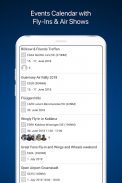
Need some ideas for your next day trip? The RunwayMap events calendar shows you events like airport festivals, fly-ins, and vintage plane shows.
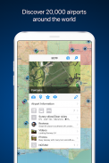
The interactive map gives you an overview of the airports. We have collected important information on every airport:
• Aviation weather forecasts
• Runways & NOTAM
• 3D and satellite views
• Webcams and much more
RunwayMap simplifies flight preparation and complements flight planning tools such as SkyDemon, Jeppesen and Garmin Pilot.
Download the versatile pilot app while you are at it.
Features:
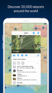
MAP
Search by name or ICAO to discover new airports. Receive important information such as the current weather, address, position, runways, NOTAM and sunrise/sunset. Mark and save what airports you’ve already flown to or those you’d like to fly to next. Save your personal notes for every airport.
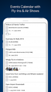
EVENTS CALENDAR
The RunwayMap events calendar shows you events like airport festivals, fly-ins, and vintage plane shows. Each event displays the distance from your home base to the event location in nautical miles, as well as which pilots from the RunwayMap community are also interested in going.
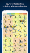
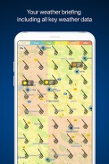
AVIATION WEATHER
Current weather reports, visual flight conditions und wind forecasts are shown on our map.
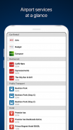
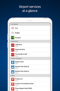
ON-SITE SERVICES
Discover restaurants and hotels near the airport. Get informed about public transport and car rental offers.
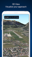
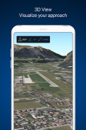
3D AND SATELLITE VIEWS
Check out the airport environment in 3D and satellite views. Use the OpenStreetMap view for detailed vehicle access information.
DOCUMENTS
With just a few clicks, add your flight documents, such as the Jeppesen approach charts, FAA terminal procedures and airport diagrams, SkyDemon manuals or the Garmin pilot’s guide. That way you always have them close at hand.
TOOLS
Use the handy calculator for conversions for distance, weight, temperature, and more. Have it display your QNH and QFE.
RUNWAYMAP APP
Important note: RunwayMap is not intended to provide aeronautical information or navigation aids. For navigation purposes, we strongly recommend using only approved and updated aviation information such as SkyDemon, Jeppesen or Garmin Pilot.
The weather data shown in RunwayMap is only general information about possible weather development. It does not replace professional weather briefing by an official body before the flight.
Learn more about RunwayMap at runwaymap.com
RunwayMap هو المجتمع التجريبي رقم 1 عن كل شغف الطيران. يمكنك مشاهدة مقاطع فيديو الطيران والتعليقات والصور من الطيارين الآخرين وكذلك مشاركة تجارب الطيران الخاصة بك.
هل تحتاج إلى بعض الأفكار لرحلتك في اليوم التالي؟ يعرض تقويم أحداث RunwayMap أحداثًا مثل مهرجانات المطارات والطيران الإضافية وعروض الطائرات القديمة.
الخريطة التفاعلية تعطيك لمحة عامة عن المطارات. لقد جمعنا معلومات مهمة عن كل مطار:
• توقعات الطقس الطيران
• مدارج & NOTAM
• وجهات النظر 3D والأقمار الصناعية
• كاميرات الويب وأكثر من ذلك بكثير
يعمل RunwayMap على تبسيط عملية إعداد الرحلة واستكمال أدوات تخطيط الرحلات مثل SkyDemon و Jeppesen و Garmin Pilot.
قم بتنزيل التطبيق التجريبي المتنوع أثناء وجودك فيه.
ميزات:
خريطة
البحث بالاسم أو الايكاو لاكتشاف مطارات جديدة. الحصول على معلومات مهمة مثل الطقس الحالي ، العنوان ، الموقف ، مدارج الطائرات ، NOTAM وشروق الشمس / غروبها. حدد وحفظ المطارات التي كنت قد سافرت إليها بالفعل أو تلك التي ترغب في السفر إليها. حفظ الملاحظات الشخصية لكل مطار.
الأحداث الجدول الزمني
يعرض تقويم أحداث RunwayMap أحداثًا مثل مهرجانات المطارات والطيران الإضافية وعروض الطائرات القديمة. يعرض كل حدث المسافة من قاعدة منزلك إلى موقع الحدث بالأميال البحرية ، وأيضًا الطيارون من مجتمع RunwayMap مهتمون أيضًا بالذهاب.
الطقس الطيران
تظهر تقارير الطقس الحالية وظروف الطيران المرئية وتوقعات الرياح على خريطتنا.
خدمات الموقع
اكتشاف المطاعم والفنادق القريبة من المطار. الحصول على معلومات حول وسائل النقل العام واستئجار السيارات.
وجهات نظر 3D والأقمار الصناعية
تحقق من بيئة المطار في 3D والأقمار الصناعية وجهات النظر. استخدم طريقة العرض OpenStreetMap للحصول على معلومات مفصلة عن الوصول إلى السيارة.
مستندات
بنقرات قليلة فقط ، أضف مستندات الرحلة الخاصة بك ، مثل مخططات نهج Jeppesen وإجراءات محطة FAA ورسومات المطار ، وكتيبات SkyDemon أو دليل Garmin pilot. بهذه الطريقة يكون لديك دائما قريبة في متناول اليد.
أدوات
استخدم الآلة الحاسبة المفيدة للتحويلات للمسافة والوزن ودرجة الحرارة والمزيد. اجعله يعرض QNH و QFE.
RUNWAYMAP APP
ملاحظة مهمة: RunwayMap غير مخصص لتوفير معلومات الطيران أو وسائل الملاحة. لأغراض الملاحة ، نوصي بشدة باستخدام معلومات الطيران المعتمدة والمحدثة فقط مثل SkyDemon أو Jeppesen أو Garmin Pilot.
بيانات الطقس الموضحة في RunwayMap هي معلومات عامة فقط عن التطور المحتمل للطقس. لا يحل محل إحاطة الطقس المهنية من قبل هيئة رسمية قبل الرحلة.
تعلم المزيد عن RunwayMap في runwaymap.com
RunwayMap: Aviation Weather & 3D Views for Pilots - إصدار 3.6.7
(22-02-2023)RunwayMap: Aviation Weather & 3D Views for Pilots - معلومات APK
نُسخة APK: 3.6.7الحزمة: ch.reddev.android.runwaymapتطبيقات من الفئة نفسها
قد يعجبك أيضًا...


